

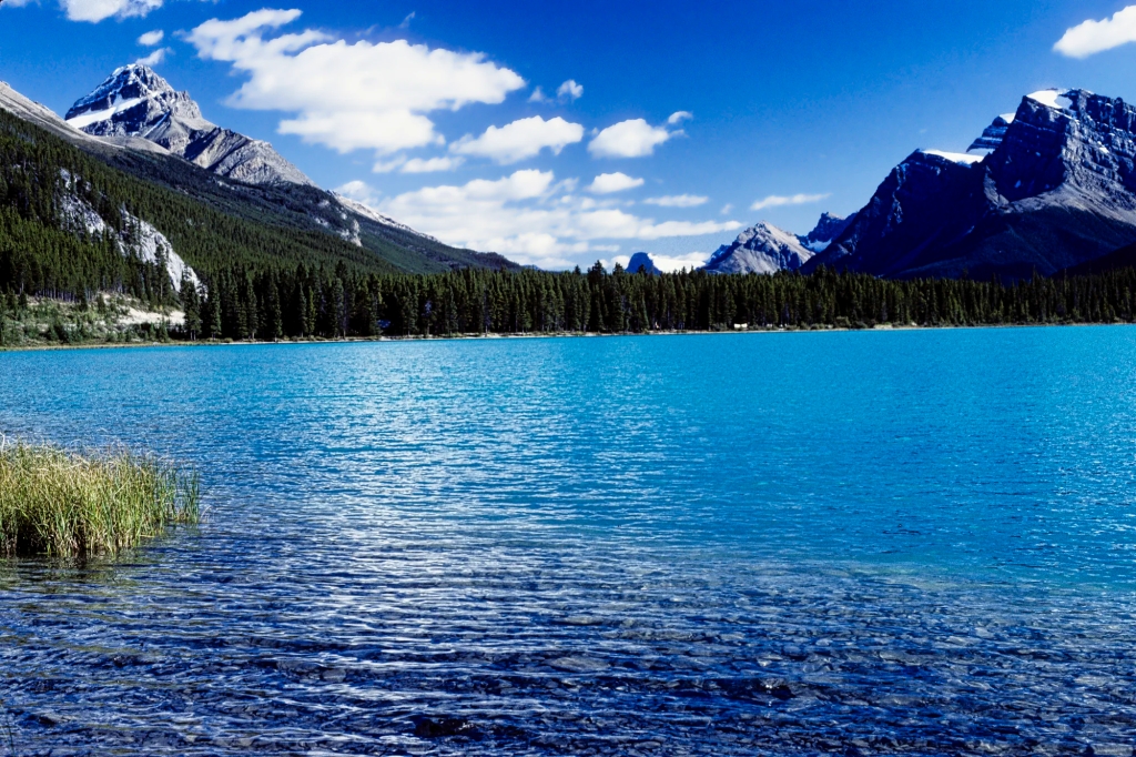
Yoho is a Cree word that means “awe” and Yoho National Park (NP) is awesome. There are three areas in Yoho NP that beg for your attention. Emerald Lake is one of our top five favourite glacial green lakes. Thundering Takakkaw Falls is the second tallest waterfall in Canada. The piece de resistance is the alpine scenery surrounding the unusual baby blue Lake O’Hara that comes with exciting hikes surrounded by high mountains.
These and other points of interest have been pinned to our custom Google map, BC Yoho and Glacier NPs Map. Our recommendations are based on our experience living in Alberta for ten years. We are avid hikers, nature lovers and photographers. The Rocky Mountains were our weekend playground.
Yoho was the second Canadian NP created in 1886 and is part of the Canadian Rocky Mountains UNESCO World Heritage site, in part due to the Burgess Shale sites featuring fossils from 540 million years ago.
Author & Photographer: George Mitchell

Our advice below is not based on a couple of tourist trips. Our recommendations are based on our extensive experience living in Alberta (AB). We are avid hikers, nature lovers and photographers (all photos are my own). The Rocky Mountains were our weekend playground. We often hosted out of province friends and family using the itinerary we are recommending.
All of our recommendations are top-rated by Google Maps Ratings, which is based on everyone, not just tourists. Each place recommended in our custom Google map, BC Yoho and Glacier NPs Map is appended with a Google Maps Rating (G0 to G5).
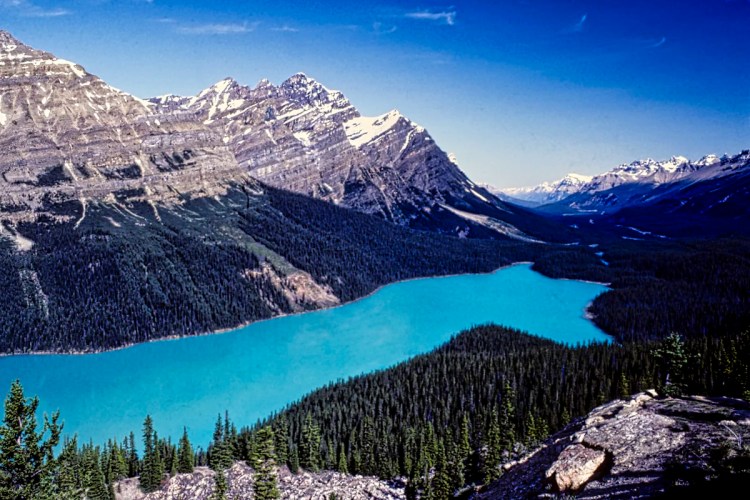
Emerald Lake
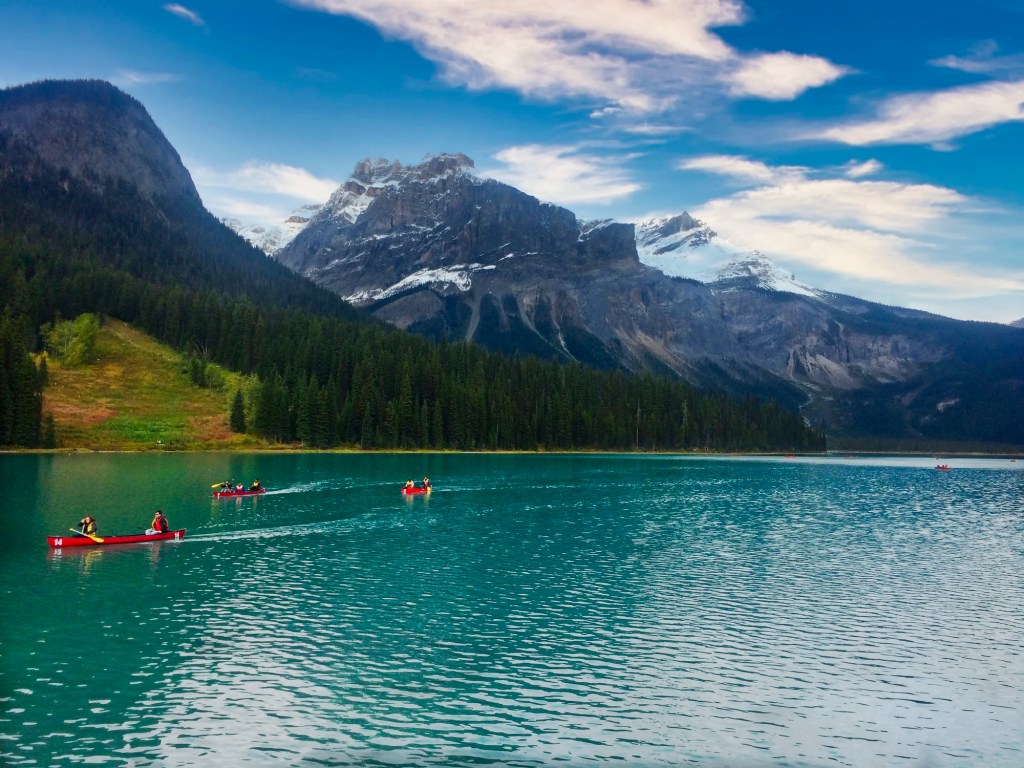
Driving to an altitude of 1884 m (6181 ft) asl, you arrive at one of our top five turquoise lakes in the Rockies. Emerald Lake really looks emerald green. What causes the blue-green colour? Blame it on the glaciers! Read why in the Icefields Parkway – Do not Miss the Best Road Trip in Canada.
Yoho has 15% of the number of visitors that go to Banff NP and Lake Louise. However, many Banff visitors also go to nearby Emerald Lake. Nowadays, in order to find parking in the limited space, come early in the morning — or late in the day but the mountains may be in the shade. You can also park further away and walk. We simply waited in the parking lot until someone left. As in any tourist place, the busiest time of the day is between 10:00 and 15:30 hrs.

The road is open year-round, but for cross-country skiing during the frigid winter in high-altitude mountains. During summer, the bridge to the lodge is crowded with tourists taking selfies. The bridge does have the best views nearest to the parking lot. Most people take a few photos and perhaps grab a coffee, then leave.
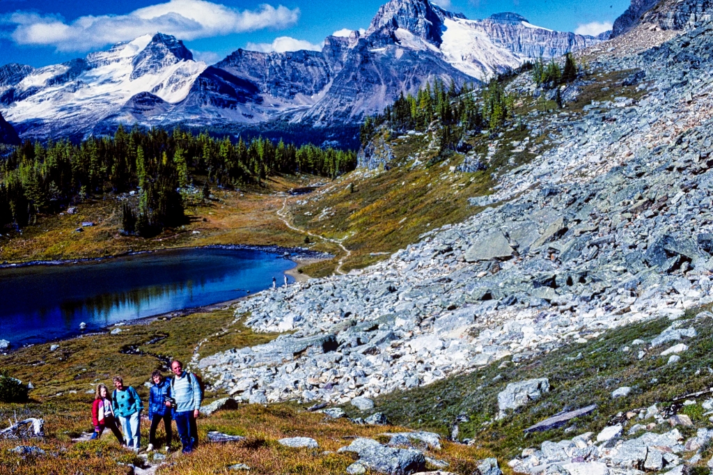
Emerald Lake Circuit Trail
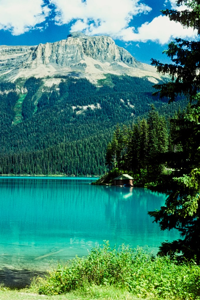
The scope of the view of Emerald Lake from the bridge is limited to a small section of the lake. Instead, you should walk on the east side along the lakeshore past the picnic area. This is a flat trail until you get to the other end of the lake, 1.4 km at the Yoho Pass Trail junction. There are views all along the way. For an easy and short walk, return the same way as the full circuit trail is 5 km.

The rest of the trail is up and down. It is also inside a thick forest of Engelmann Spruce and Western Red Cedar. There are no views until you return to the Lodge. In the winter, this loop becomes a cross-country trail. We came here on the weekend to avoid the downhill crowds at Lake Louise and Sunshine.
Yoho Pass – Burgess Pass Loop Trail
We walked this trail with my sister and brother-in-law, who are novice hikers. We combined parts of three hikes described in the Canadian Rockies Trail Guide (see below). The first part of the trail was the flat lakeshore walk. At the end of the lake we made a left turn up a steep, partial ascent of The President and Michael Peak to Yoho Pass. There are a couple of trail options here as well.
From Yoho Pass at km 6.3 we had a dramatic view of Takakkaw Falls, which is straight across the Yoho Valley. You can see part of the Daly Glacier on top of the massive Mt. Daly but you cannot see the glacial lake behind the mountain top. Unfortunately, the weather was too hazy for a good photo but it’s the only image I have. I replaced the pure white sky as well using my photo editor.
Over halfway through the loop, we came to an un-bridged brook that was now a gushing torrent. It had been raining earlier but we decided it was better to continue on. Even worse, the crossing had a very steep drop off cliff on the right side. You do not want to fall the wrong way. As we had hiking boots, we formed a line across the stream. We helped the non-hikers to cross the rocks someone had laid down. They were real troopers and did not complain.
We continued south along the shoulder of Mount Burgess and reached Burgess Pass after about 6 km. Here we turned onto the forested trail west and downhill 6.8 km to Emerald Lake.
Yoho Pass – Burgess Pass Loop Trail:
> 19.1 km, > 8 hrs RT; gain 296 m (969 ft);
Elevation: Yoho Pass 1830 m (6000 ft); Burgess Pass 2180 m (7150 ft);
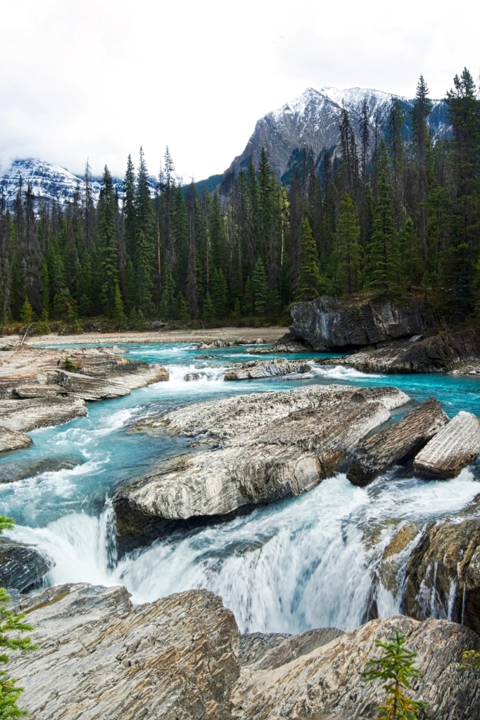
Natural Bridge
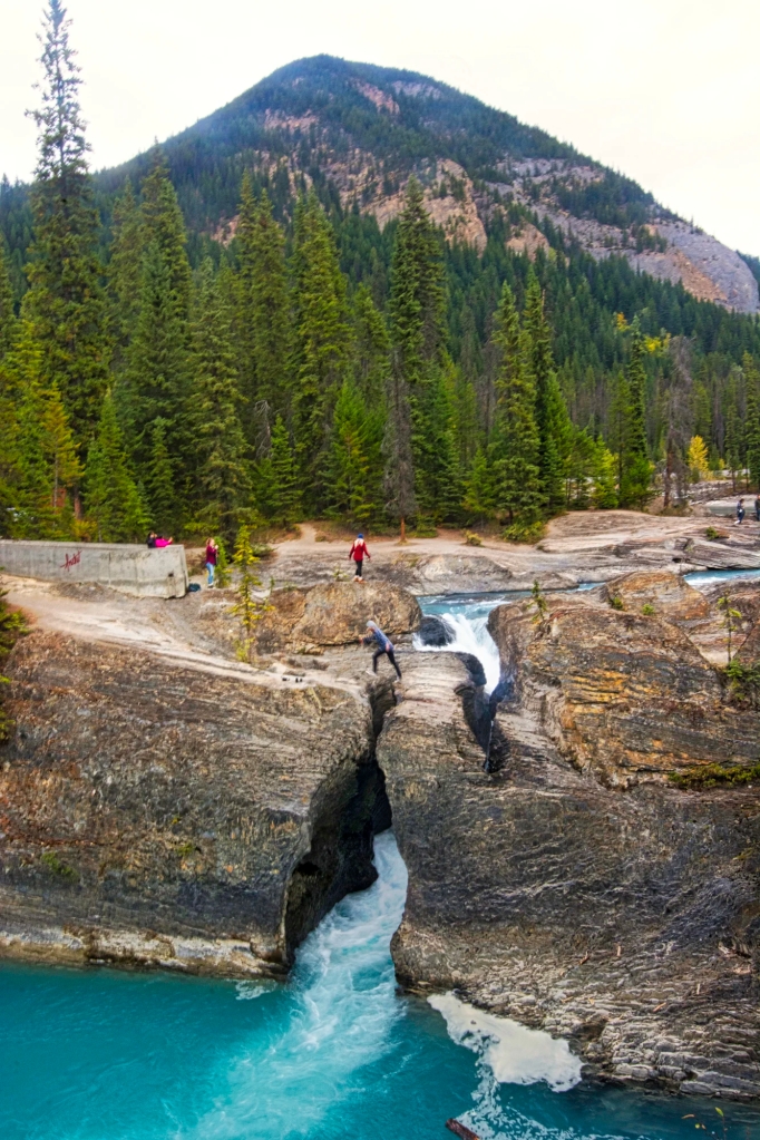
The Natural Bridge is right on the Emerald Lake Road. Stop off on the way down to the Trans Canada Highway. Don’t try the antics of this tourist that I photographed leaping over the gap. He was trying out for the Darwin Awards.
Kicking Horse River
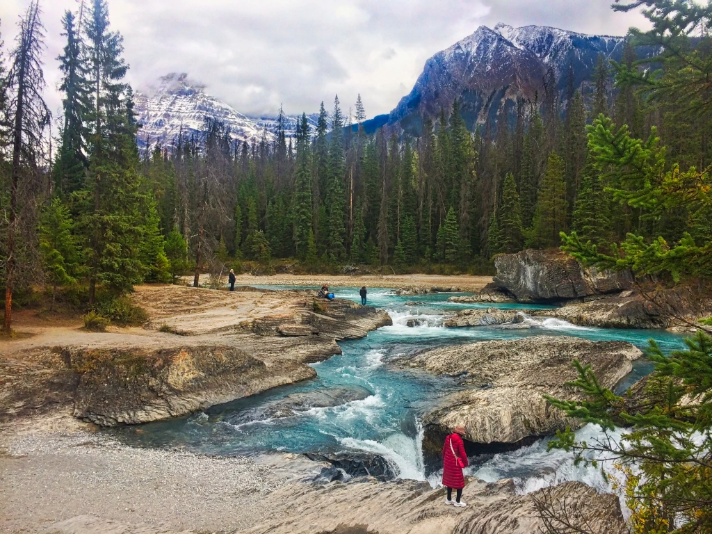
Walk upstream for views of the glacial green river that originates from glaciers on the continental divide. In 1858, James Hector was kicked by his horse attempting to cross the swift-flowing waters of this river. After being thought dead, Hector came back to life and named it the Kicking Horse River.
James Hector was a surgeon and geologist to the Palliser Expedition (1857 to 1860). He searched for a pass through the Rockies. The Kicking Horse Pass was the route chosen to build the Canadian Pacific Railway (CPR). It linked Canada to British Columbia (BC) in the 1880s.
One of BC’s best coffee roasters is named Kicking Horse Coffee. Located in Invermere at the western edge of the Rocky Mountains, their beans are now exported across the country.
Spiral Tunnels Viewpoint
The Spiral Tunnels, considered an engineering feat, were completed in 1909. It consists of two enormous loops tunnelled through the mountains allowing the desired 2.2% gradient, the typical standard.
The Spiral Tunnels Viewpoint is on the westbound side of the Trans Canada Highway, about five miles east of the town of Field. The original railway travelled down a dangerous 1000-foot descent called the Big Hill that caused accidents.
To complete the CPR route as quickly as possible, a decision was made to not blast a lengthy tunnel through Mount Stephen. Instead, a steep 13 km line with a 4.5% grade was built in 1884. The first construction train to go down the pass ran off the hill landing in the Kicking Horse River. The rail line was also subject to avalanches and landslides. The village of Field was created solely to add locomotives to trains about to tackle the Big Hill.
It’s not the most scenic viewpoint unless a train happens to come by. But it’s worth the stop for its historical significance. The railway was a condition for British Columbia joining Canada rather than the United States. Yes, that was a possibility! This was caused by the influx of American gold prospectors during the Cariboo Gold Rush. See the post, Barkerville, the Town that Changed the History of Canada.
About 1000 people worked on the Spiral Tunnels for three years at the cost of about $1.5 million in 1909 or $50.4 million in today’s dollars. Wages were much lower then.
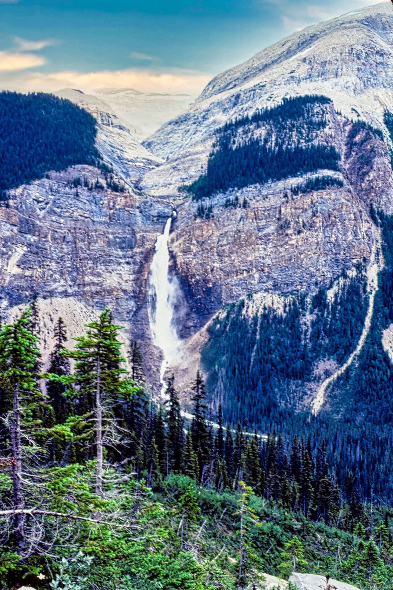
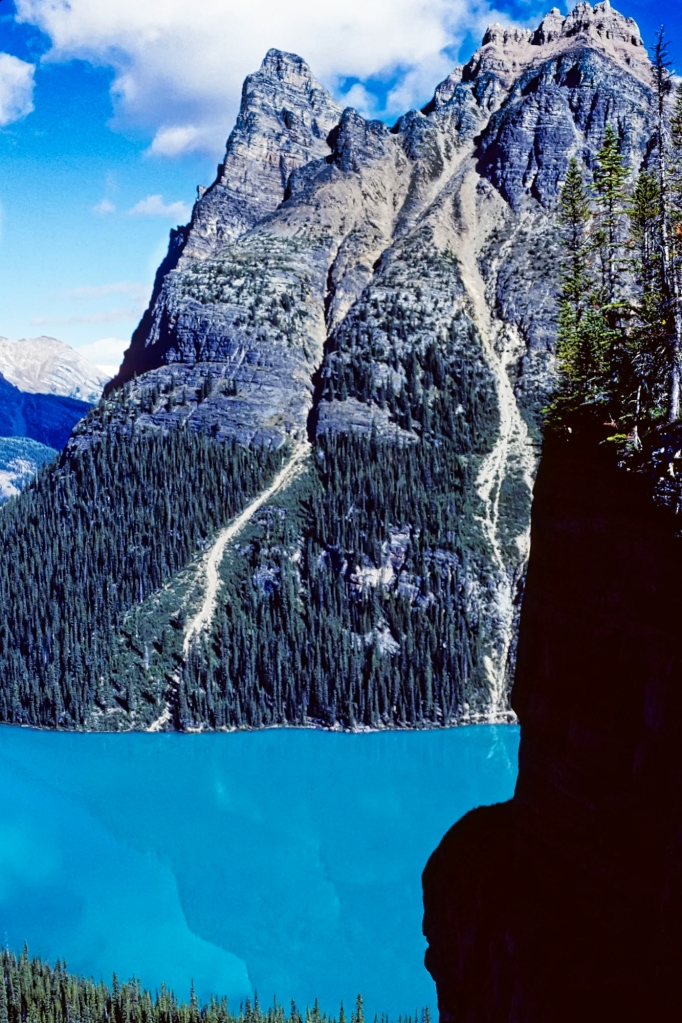
Takakkaw Falls
The Yoho Valley road is narrow and winding, with a series of scary 270’ switchbacks. Camper vans and trailers are not allowed. On the way up is a minor stop, Meeting of the Waters, where the Yoho and Kicking Horse Rivers merge. The cloudy Yoho and clear Kicking Horse are both glacier-fed. The size of the silt suspended in the water affects the colour.
From the falls parking lot, cross the bridge over the Yoho River and take the trail to the bottom of the falls.
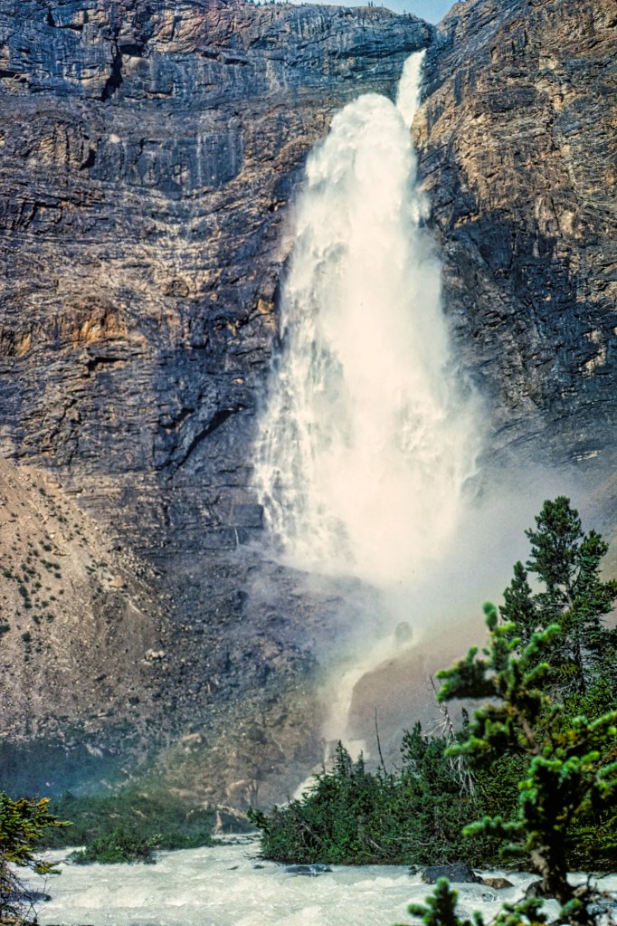
We suggest you come here after Emerald Lake as there is better sunlight for photos of the falls in the afternoon. Takakkaw Falls faces west.
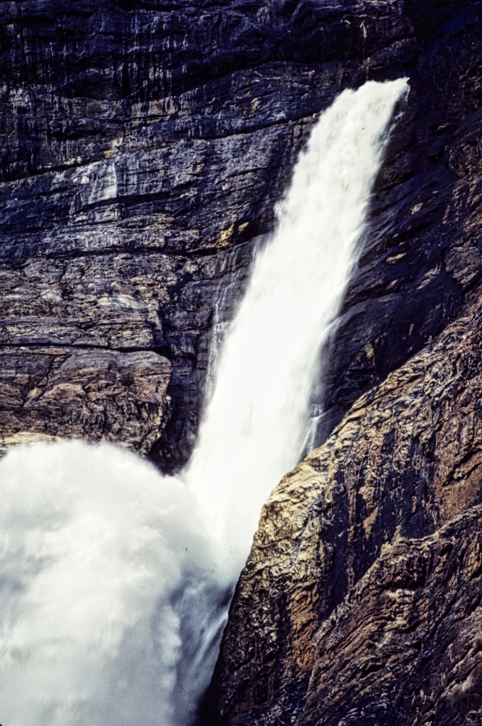
Takakkaw is a Cree word meaning “magnificent”. Indigenous names are far more descriptive than the European names. In fact, the cardinal rule in place names is that the original explorer gets to assign the name. We should therefore be using the Indigenous names. These magnificent falls are the second-highest in Canada. They plunge over a sheer wall of rock more than 366 m (1200 ft) to the bottom.
Fun Fact: so what is the tallest waterfall in Canada? It is Della Falls, the 16th-highest falls in the world with a 440 m (1444 ft) drop. It is located on Vancouver Island, BC.

After pounding onto a ledge part way down, Takakkaw catapults in a free fall for 259 m (850 ft). The waterfall is fed by the Daly Glacier at the top, and is at its best in July. To us it was always a thundering falls feeding the Yoho River, a major tributary of the Kicking Horse River.
If you have time, return back to Lake Louise by the quieter original road now labelled Highway 1A to the Great Divide viewpoint.
Twin Falls Trail
We only did a small part of the Twin Falls Trail that heads upstream along the Yoho River north from the parking lot. It reaches Laughing Falls after 4.7 km, which is a good destination for a short hike.
Twin Falls Trail is the return route for the Highline loop trail, which joins it at Laughing Falls. One website claims it’s the best hiking trail in the Rockies, which is confirmed by the Canadian Rockies Trail Guide book. Highline was constructed at high altitude thanks to a request to the CPR by British climber Edward Whymper. Whymper, the first person to climb the Matterhorn, came to Yoho NP in 1901.
Twin Falls Trail:
8.5 km 3 hrs OW; gain 290 m (950 ft), elevation 1800 m (5900 ft);
Highline or Iceline Trail:
24.4 km 1.5-2 days OW; gain 840 m (2750 ft), elevation 2090 m (6850 ft);
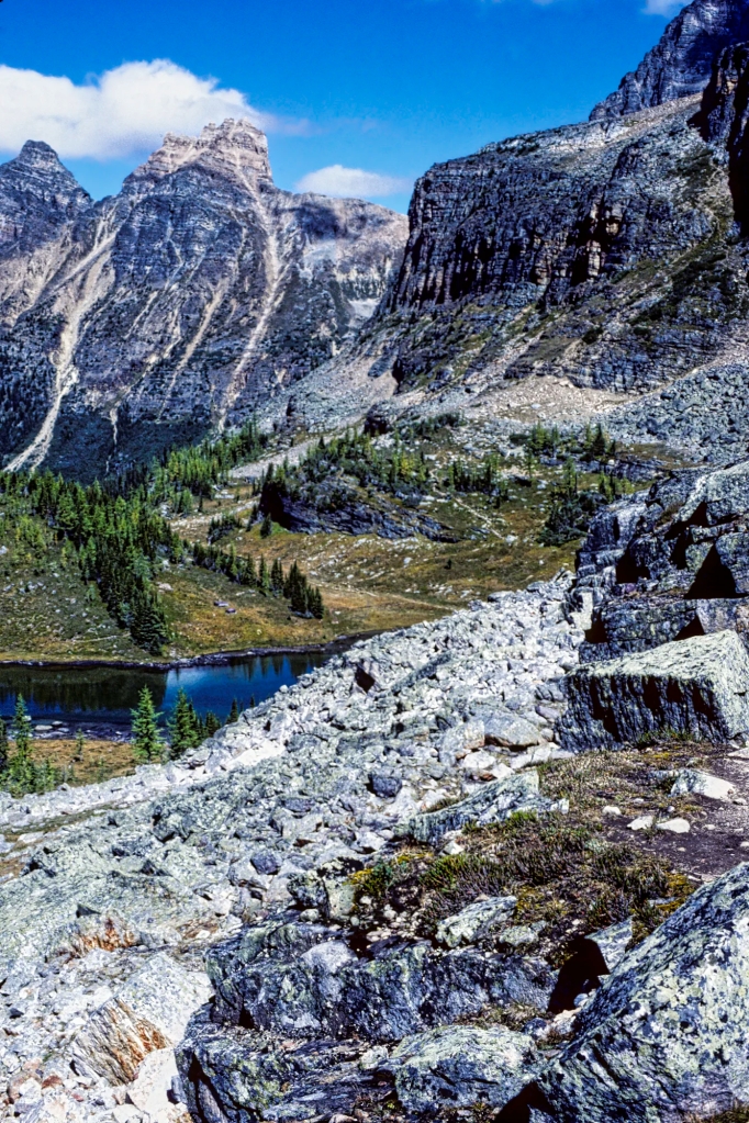
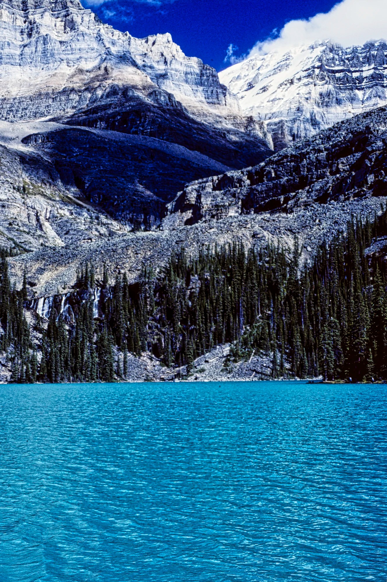
Lake O’Hara

Lake O’Hara, located at 2020 m (6,630 ft) asl, is spectacular as well as peaceful. The area is named after Lieutenant-Colonel Robert O’Hara, from Galway, Ireland, who served in Newfoundland. He did not discover this area but was probably the first tourist.
There are many fewer tourists compared to lakes like Moraine and Louise. In fact, we met no other people during the whole day once we left the Le Relais shuttle bus stop. This is because unless you bike or hike the 11 km restricted access road, you need to make advanced registration to travel on the shuttle bus. Most distant tourists do not know this, and this makes access impossible to obtain seats at the last minute. The logistics are discussed below in the Where to Go in Yoho NP section.
Opabin Plateau Trail
The Opabin Plateau Trail is a moderately challenging climb of 407 m (1335 ft) through scree and rocky terrain. The All Trails web site states it is a 3 hour, 8.7 km loop trail. However, because we were guiding our Kiwi friends and their two teen daughters, we shortened the route. We did not go north and walk all around the east side of Lake O’Hara. We headed south along the west shore and then climbed up to join the East Opabin trail.
Because the trail goes into the alpine, there are wide open views of the mountains.
Wiwaxy is the Stoney First Nations word for windy. Wiwaxy Peaks (2706 m, 8878 ft) are composed of sedimentary rock laid down during the Precambrian period. It’s hard to believe these date back to the earliest period of the history of Earth.

Higher up, Hungabee Lake and Cascade Lakes are sprinkled along the trail. The upper portion of the Wiwaxy Peaks is reflected in the lake.
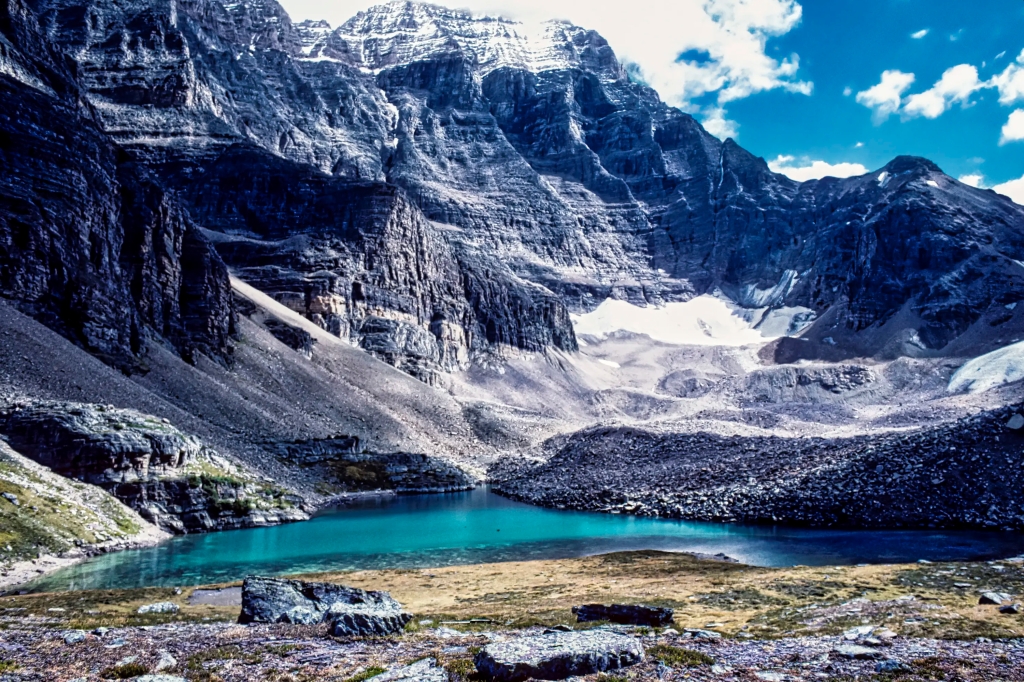
Opabin Lake (2277 m, 7470 ft) is the major feature on the Opabin Plateau. It is a hanging valley located above Lake O’Hara.
We descended on the West Opabin Trail. There is a side trail to Opabin Prospect, an amazing panorama of Lake O’Hara and the surrounding mountains. This is the iconic viewpoint of Lake O’Hara. As we were guiding our Kiwi friends and their two teenage daughters, we did not do this special side trail. The daughters were more interested in going shopping at West Edmonton Mall in Edmonton.
Opabin Plateau Trail: 5.9 km 3 hrs loop RT;
gain 407 m (1335 ft), elevation 2270 m (7448 ft);
On the way back, we joined the Lake O’Hara Shoreline Trail. This is ideal for non-hikers who want to experience amazing mountain scenery.
Mt Victoria (3464 m, 11,365 ft) is the West Side Story of the famous mountain that frames Lake Louise. Mount Victoria is composed of sedimentary rock laid down during the Cambrian period. To the right, Mt Lefroy (3423 m, 11,230 ft) was the subject of a prominent painting by Canadian Group of 7 artist Lawren Harris.
Lake O’Hara Shoreline or Adeline Link Trail:
2.8 km 1 hr loop RT;
gain 54 m, elevation 2270 m (7448 ft)
Lake O’Hara Alpine Circuit is an all-day hike to Wiwaxy Peaks, Mt. Huber, Lake Oesa, Hungabee Lake, and All Souls’ Prospect. It’s one of the more difficult options.
Lake O’Hara Alpine Circuit Trail:
11.1 km 5 hrs loop RT; gain 887 m (2910 ft)
What to Wear in the Canadian Rockies
If you go to Lake O’Hara, you are going to be totally isolated. Food, clothing, and equipment you carry with you are important. In fact, whenever you are hiking in the mountains, you need to bring layers of clothing as the weather in the alpine can vary from sunny to wintry in one day due to the altitude.
It snowed on us in Kootenay NP in July! We always use hiking boots, hiking or sports socks, a Patagonia sweater, and a Gore-Tex jacket. Also, bring a pair of gloves in case you experience cold weather. Do not forget a water bottle. We always wore a day pack to carry the unused layers of clothing and camera equipment,
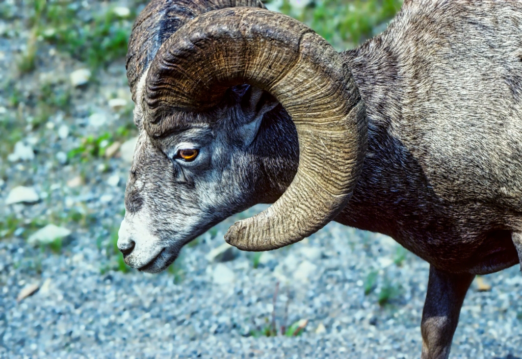
What wildlife can I see in the Rockies?
To see wildlife, you probably need to go searching in early morning or late afternoon/evening. Note that sunset is at 22:00 hrs in June!
The animals most people want to see are Bighorn Sheep, Mountain Goats, Bears, Moose, Deer, and Wapiti. There are two other animals that we most identify with the Rocky Mountains. The can only be seen by hiking. The marmot lives in ground boroughs or rock slides near timberline. They are often seen getting a suntan. The big-eared, tiny pika lives in sub-alpine or alpine rock slides.
What wildflowers can I see in the Rockies?
The flowers of the Canadian Rockies can be found on many subalpine and alpine hikes. You just need some sunlit areas. The issue is not where but when. Because of the high altitude, the best time for wildflowers depends on when the snow has melted. Sometimes this can be late June; sometimes late July. This means you usually need to go hiking in July-August.

Columbine is a beautiful wildflower in Banff NP. It is found in subalpine forests and is common in early summer.
Where to Eat in Yoho NP
Dining out is very limited in Yoho NP. There is no nearby town. The options are limited to the poorly rated Cilantro Café (Google rating 3.4) at Emerald Lake and the highly rated Truffle Pigs Bistro (4.5) and The Siding Café (4.6) in the village of Field. Google ratings are based on the opinions of all people, not just tourists. Any rating between 4.0 and 4.4 is Very Good (VG), and ≥ 4.4 out of 5 is Excellent (E). See locations on our custom BC Yoho & Glacier NPs Itinerary Map.
Le Relais on Lake O’Hara has snacks and supposedly the best carrot cake ($6, but bring cash).
Usually, we bring our own food to Yoho and have a picnic. We always buy non-perishable food (cans) and some fruits and vegetables in Edmonton/Calgary and fill up on gas before hitting the more expensive Rockies. We store our food in old milk delivery crates or our plug-in cooler in our van. We never put aromatic fresh food in our backpacks due to the bears. Don’t forget light-weight backpacking cutlery.
Where to Stay in Yoho NP
Yoho NP has Kicking Horse Campground (Google 4.2, tent sites $29.25) and Monarch Campground (Google 3.5, primitive sites $18.75).
For Lake O’Hara, there are only two options: Lake O’Hara Lodge (Google 4.3, $860 (ouch) for a double full board) and Lake O’Hara Campground with 30 sites for a maximum stay of 3 nights (Google 5.0, backcountry sites $12.75 per person).
There are a few rooms available at about 12 guesthouses in the village of Field. You can find their contact number and booking web site on Google maps. This is a small village of only 195 people, so there are not many options. All villages and towns in the Rockies are owned by Parks Canada and cannot just expand.
Generally, we stay at a base in Lake Louise Village and commute to Yoho. Another alternative would be the town of Golden, BC, which we researched for our last trip. Golden has several VG-rated places like Best Western, Canyon Ridge Lodge, Pinewood Inn, Kicking Horse Guest House, Rooms at Riveredge, Brookside Motel, and Dreamcatcher Hostel. Many of the other hotels have very poor ratings.
What to Read about the Rockies
The two books should be available in any bookstore in Alberta and are on Amazon.
- Parkways of the Canadian Rockies (Brian Patton 2008, CAD 24.47) is like bringing a naturalist along to interpret what you should be seeing.
- Canadian Rockies Trail Guide (Brian Patton & Bart Robinson 2022, CAD 29.95) is the best hiking book we have seen or used in all our travels around the world.
- Yoho NP Website (Parks Canada)
- Yoho NP Visitor Guide (Parks Canada)
- Yoho NP Hiking & Map (Parks Canada)
- Travel Tips page provides advice that applies to any trip (you can access via the Terra Encounters menu as well).
Where to Go in Yoho NP

To save you time we have designed a custom BC Yoho & Glacier NPs Itinerary Map with estimated distances and driving times.
Parks Canada Passes
Since the Trans-Canada goes through Yoho NP, you can transit through the park without any fees. But the minute you park, hike, drive on the side roads, or do some other activity — you must have a NP pass. The day pass is $10.50 per person. The annual Discovery Pass is $72.25 for all 80 Parks Canada sites. There are no multi-day passes. There are discounts for children and seniors.
Lake O’Hara Shuttle Bus
Lake O’Hara requires reservations because access is restricted to park shuttle buses. These are extremely difficult to obtain unless you log into the Lake O’Hara reservations system when it opens; e.g. at 8:00 MT, April 12, 2023. You will be added to the queue and will be able to book whatever time slots and days remain when you get to the front of the virtual queue.
The shuttle bus drives 11 km to Lake O’Hara and costs $17.14 return per person. It operates from ca. June 18 to October 3. Day-use bus schedule ingoing: 8:30 and 10:30, and outgoing: 9:30, 11:30, 14:30, 16:30, and 18:30 (MT). The only alternative is to hike 11 km OW on the road.
Other Planning Information
We have compiled additional tips and advice. Topics include Rocky Mountains Itineraries, Parks Passes, Travel by Car, Best Time to Visit the Rockies, Other Places to Add to Your Itinerary, and Canada FAQ. You can read these topics in the Ravishing Rockies Portal post.

9 thoughts on “Yoho National Park – 3 Awesome Sights in the Rocky Mountains”