
Why Do the Thunder Bay Road Trip?
Why should you drive across North America via Thunder Bay, Canada? Along the way, you can see many beautiful bays and peaceful beaches on the ocean-like Lake Superior. But did you miss three sights near Thunder Bay that make this road trip worthwhile? One site is historic, and two are scenic — a spectacular waterfall and a dramatic canyon.

And the best part? There are much less people swarming the beaches and videoing the sights. It is a much safer place and more relaxing drive. There is a lot less city traffic and a lot more wilderness.
Welcome to another episode in our 19,000 km road trip across Canada. Actually, we have crossed North America via USA and Canadian routes at least eight times.
Author & Photographer: George Mitchell

Our recommendations are not influenced by affiliate links – we have none. Our advice is derived from our personal experience and knowledge based on living in Western Canada.
All of our recommendations are top-rated by Google Maps Ratings, which is based on everyone, not just tourists. Each place recommended in our custom Northern Ontario Itinerary Map is appended with a Google Maps Rating (G0 to G5).
Sault Ste. Marie to Thunder Bay

There are two themes to this road trip: lots of water and lots of trees.
The water is Lake Superior, the largest freshwater lake in the world, holding 10% of the world’s surface freshwater! It is about the size of Austria, Serbia, or South Carolina.
It is hard to believe this huge lake was created by a glacier. Actually, it was really a mile high ice sheet that covered most of North America. This giant bulldozer began retreating about 11,000 years ago, and its meltwaters filled the scoured-out rift. It looks like an ocean.
We realized that just seeing a wide expanse of water is not very photogenic. Scenic landscapes need foreground frames like formations along the road or islands in the water. That’s why we stopped by the side of the road to take the above photo.

The trees are the perpetual forest that lines the Trans-Canada Highway, the only main road through Northern Ontario. It can be difficult driving through an endless forest. One year, we drove back in early September — our son’s teacher was not too impressed that he missed several days of school. On the plus side, every turn on the road revealed more gold, orange, and red fall leaves. It was peak autumn leaf time. The reason it is so early is that we are at the 48th parallel, so the leaves change earlier.
But, the focus of this post is Thunder Bay at the end of Lake Superior. Here you will find some of the best places of the whole itinerary, the best reasons to do this road trip.
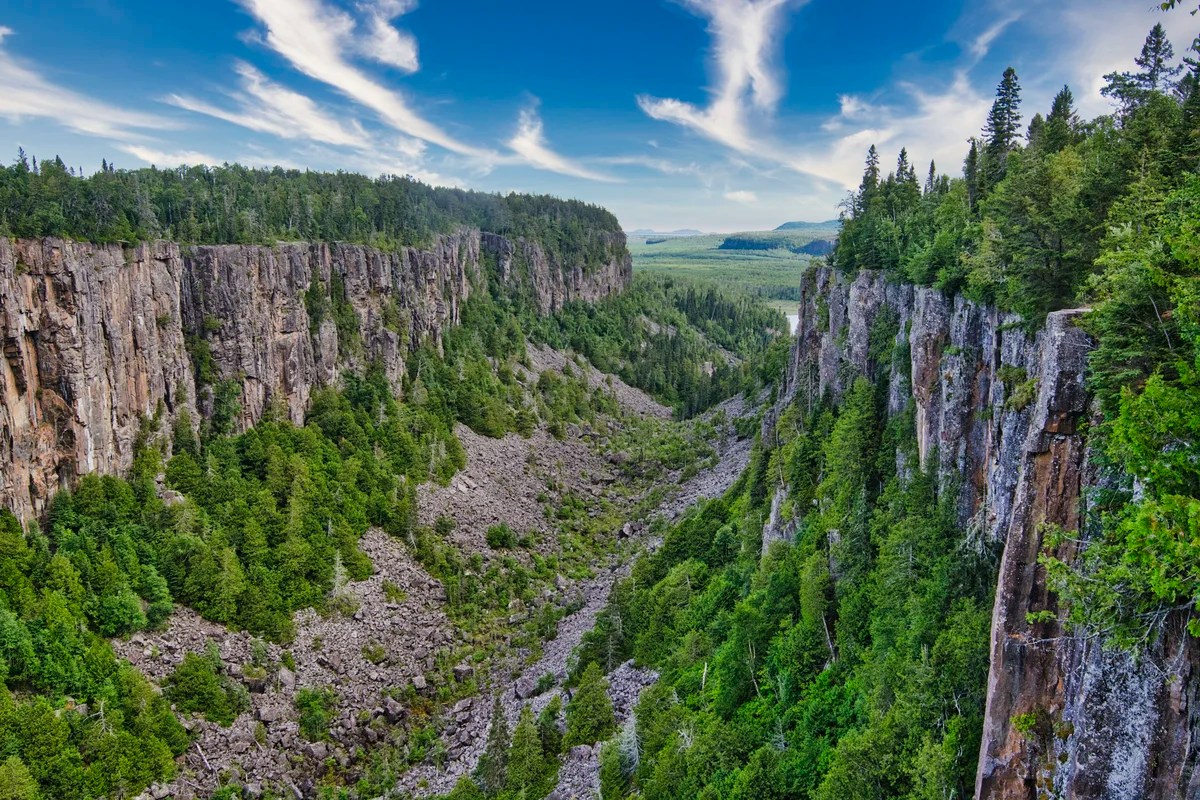
Ouimet Canyon

About 60 km (37 mi) northeast of the city of Thunder Bay, we drove 11 km off the Trans-Canada to Ouimet Canyon Provincial Park. An easy 1.8 km trail leads to two viewing platforms overlooking the canyon. It is quite a steep 100 metre drop from each lookout.
Each platform provides a wide view up and down the 150-metre-wide gorge lined with volcanic columns.

Geologists believe that Ouimet Canyon was created 1,000,000 years ago when glaciers came through northern Canada. This created a large crack that wind, rain and ice have etched out into a beautiful canyon.

The canyon rim is covered with boreal forest. The canyon floor is covered in sub-arctic tundra, plants that are normally found one thousand kilometres further north. Why?
Short periods of sunlight, 30 cm (12 in) blankets of moss, and unmelted ice shaded by the moss and boulders create a cold micro-climate that supports subarctic plants. Plants like liverworts and alpine wintergreen came with the glaciers. For this reason, the canyon floor is off-limits to tourists.

A large rock column known as the Indian Head can be seen from the northern viewing area.
Terry Fox Monument

Terry Fox is a folk hero across Canada. After losing his right leg to cancer at age 18, he decided to run across Canada to raise awareness and money for cancer research. At that time, cancer outcomes were very poor compared to today. I lost nearly every aunt and uncle to cancer on my mother’s side of the family.
Marathon of Hope
Using one of the first running prosthesis, Terry Fox set out from St. John’s, Newfoundland, on 12 April 1980 and covered 5,373 km — an average of 42 km (26 miles) per day. He was running a marathon every day and appropriately the campaign was called the Marathon of Hope.
Nobody knew who he was, and he hardly got any coverage. By the time he reached Ontario, Fox met the Prime Minister and some famous hockey players, and became a celebrity. Suddenly, residents would stand along the road as Fox ran through their town.
Terry Fox Memorial
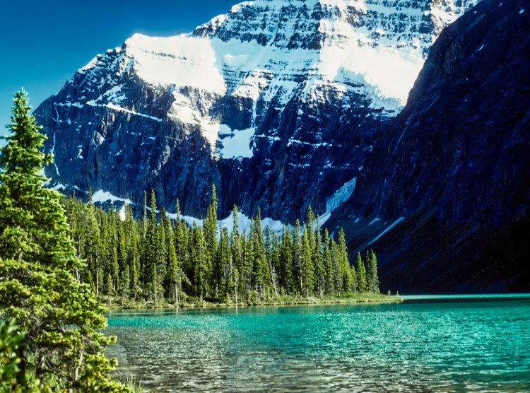
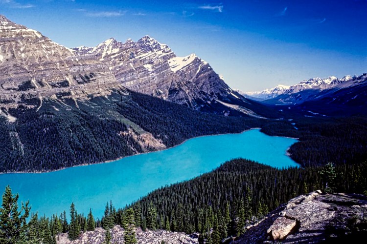
On 1 September 1980, Fox was forced to stop the run in Thunder Bay when cancer had invaded his lungs. The Terry Fox Memorial and Lookout was built in 1982. It marks the place where Fox ended his run, which was actually 2.5 km away on the original two-lane highway. They moved the memorial here on a hill so that they could also make a viewpoint of Lake Superior and Sleeping Giant, a provincial park that is worth visiting.
The annual Terry Fox Run, first held in 1981, has grown to involve millions of participants in over 60 countries and is now the world’s largest one-day fundraiser for cancer research. Over CAD 850 million has been raised in his name as of September 2022. He finished second to Tommy Douglas in the 2004 Canadian Broadcasting Corporation reality TV program to choose The Greatest Canadian.
Thunder Bay
This city is always our stopover before heading to or from Winnipeg. It has lots of places to stay and eat out. If you travel off-season across Northern Ontario, many motels in the small towns are closed down, so you need to rely on the major cities. There are also several sights south and east of the city, such as Fort Williams Historic Park, the original fur trade site.
Kakabeka Falls

The 40 metre high Kakabeka Falls is the second highest waterfall in Ontario. In other words, second to Niagara Falls. It really is a beautiful sight. This is the view from the east side.
Excellent views of the falls and gorge can be seen by taking the trail over the bridge to see the falls from the west side.
The Kaministiquia River has cut deep into the rocks to create the falls. The name “Kakabeka” comes from the Ojibwe word waterfall over a cliff. These cliffs are composed primarily of unstable shale, so keep away from the edge.

The Kaministiquia River is flows into Lake Superior at the city of Thunder Bay. It was part of the historic route of the fur trade Voyageurs. In other words, rivers were the Trans-Canada of the fur trade era.
Obama Eagle, chief of the Ojibwa tribe of this area, had one child, a daughter, Green Mantle. Legend states that she was captured in her 17th summer by an invading Sioux tribe. The Sioux warriors hold her captive and force her to guide them to the Ojibwa camp. She paddles her canoe furiously along the Kaministiquia River, leading many of the Sioux warriors over the falls to their deaths, sparing her tribe from the attack. At the last minute, she leaps from her canoe onto the west shore and runs down the portage trail to warn her people. The Ojibwa defeated the Sioux. Some stories claim she sacrificed her own life.
Final Comments on this Itinerary
This is an action-packed itinerary where you can enjoy nature and wilderness without overtourism and high traffic.
Subscribe
Get travel tips and advice delivered directly to your inbox. The best part is that it is free.
If you liked our post please press the Like button at the bottom; or even better, add you own comments, questions, or places you have enjoyed.
Itinerary Map & Resources
Northern Ontario Itinerary Map — our custom Google Map
Google Maps Ratings
Google Maps provides a rating from 0 to 5 for all sights, hotels and restaurants (but not cities). All of our recommendations are appended with the rating (prefixed with a G) from Google Maps. As it is based on feedback from tourists and locals, it is much more reliable than travel booking websites. We consider a score of 4 to 4.39 to be Very Good; 4.4 to 5 to be Excellent.
Other Places to Add to Your Itinerary
If you are heading east or west of Thunder Bay, see the following posts:
Canada FAQ

The Exploring Canada post answers Frequently Asked Questions (FAQ) such as:
- Where should I go in Canada?
- What is the best season for travel?
- What is the best clothing?
- Where should I go? What are the must-sees?
- How much time do I need for Canada?
- Can I see everything in a week?
- How safe is Canada?

Leave a comment